Vélo Birmingham improves road user and resident experience by communicating live road closures and re-openings.

The Challenge
Vélo Birmingham is the flagship event of the Birmingham Cycle Revolution and played host to 15,000 cyclists who took on the unforgettable 100-mile journey. Due to the scale and numbers participating, it was necessary to implement road closures across the full route to facilitate the safe passage of the participants.
Road closures are disruptive to drivers, residents and business alike, but are an essential factor in operating a successful event. Effective communication helps to minimise the disturbances these cause.
To ensure this was done in the most effective way, Vélo Birmingham used Elgin’s Traffic Management Module with Live Link add-on to plan and communicate live road closures and re-openings.
Key Benefits
Effective communication of road closures
to drivers, residents and businesses.
Instant update of road closures and openings
direct to sat-nav services.
Minimised congestion around the route
with optimised route choice.
“The system proved to be vital in making sure residents and road users were aware and could prepare for road closures, especially as these happened across the full route. The fact that we were able to inform of live re-openings as soon as they happened and that this was communicated so widely ensured disruptions were kept to a minimum."
Active Sports & Entertainment Ltd (Vélo Birmingham)
The Solution
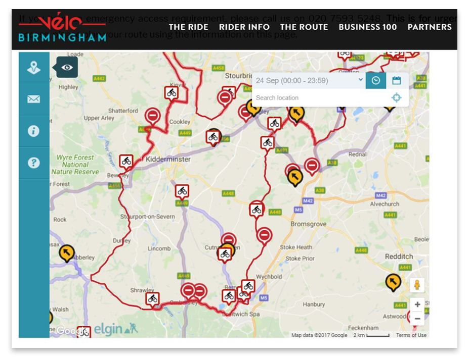
The organisers, Active Sports & Entertainment Ltd used the Traffic Management module to easily plot and publish, nearly 50 road closures. These could be viewed on the Vélo Birmingham website embedded route map, on one.network website and syndicated to a host of other websites and social media channels.
Then, using the Live Link Add-on, during the event they provided minute-by-minute updates of closures and re-openings to sat-nav services such as Google Maps. This ensured that drivers knew exactly which routes they could take and helped minimise congestion around the route.
With this solution, public event organisers, traffic management professionals and control room operators can signal the precise moment when road closures come into force and when roads are reopened. Within minutes anyone using Google Maps and other consumer services can see the change reflected on their device, reaching tens of thousands more affected citizens than is often reached by official websites.
This real-time technology gives traffic management officials the ability to reflect the situation on the ground onto the devices drivers and residents use for navigation and journey planning in real-time.
Please contact us for more information.