The Isle of Man (IoM) Department of Infrastructure (DOI) is responsible for all things transport – including the planning, coordination and communication of all highways maintenance and improvement works. In addition to their transport duties, the DOI also plays a crucial role in overseeing major events, most notably the historic Tourist Trophy (TT) Races.
The Challenge
Since its inception in 1907, the TT Races have enthralled motorsport enthusiasts worldwide. Over 77,000 spectators come annually to watch the world’s greatest road racers ride the 37.73-mile Mountain Course on the island’s public roads.
However, every year the IoM DOI faced a recurring communication challenge around the event; around 10 to 20 motorists every year attempt to drive down closed roads, following their sat-navs, which unfortunately did not always account for temporary road closures or changes to the network.
This was particularly common on the A18 Mountain Road, which transforms into a one-way route for the duration of the two-week event.
The races’ long-standing history compounded the issue, as alterations to road closure plans each year led to heightened confusion among drivers.
Driving against one-way systems and on closed roads is dangerous under any circumstances, but the collision and fatality risks escalate significantly in the absence of speed limits and with the presence of high-performance motorcycles on the roads.
The DOI recognised that safeguarding road users during the races was of paramount importance, and they were keen to also improve general navigation around the island for TT Races visitors and island tourists alike.
Therefore, the DOI sought to take proactive measures to enhance communications and road safety on the Isle of Man.
Key Outcomes
Zero instances of motorists using sat-navs that drove the wrong way
since the introduction of the TT Races one-way system on the A18 Mountain Road section in 2005.
Reduced telephone queries into DOI phonelines
by empowering the public to self-serve and plan their journeys via one.network.
Improved emergency services ability to respond to incidents
with the power to communicate closures to sat-nav apps in near real-time.
"Live Link allowed us to get the right information to the right people at the right time, without relying on confusing language. We could communicate the closures directly to the sat-nav apps the public were already using.”
Isle of Man Constabulary
The Solution
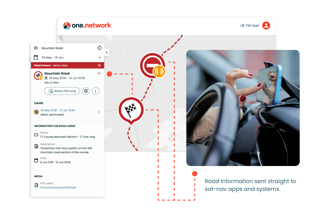
For the 2023 TT Races, the IoM Highway Services Regulations Team trialled one.network and Live Link – one.network’s real-time road and lane closure solution.
Throughout the event, the Force Incident Managers worked with the IoM Constabulary, using Live Link to close roads across the island and push the information out to all major sat-nav apps in near real-time. This included Google, Apple Maps, Waze, TomTom and Here Technologies.
To ensure seamless communication and accessibility for the public, every planned closure was also pre-published on the one.network map and shared via the Isle of Man’s Facebook page, granting clear visibility to the public and providing local radio stations with an accurate and up-to-date source of information.
The results?
Thanks to Live Link, for the first time since the introduction of the TT Races one-way system on the A18 Mountain Road section in 2005, there were zero instances of motorists using sat-navs that drove the wrong way.
Members of the public received closure and disruption information straight to their sat-nav apps, allowing them to navigate around the island smoothly and safely.
Darren Bradford, IoM Highways Regulations and Events Officer, said: "Live Link was an absolute must during TT. It was simple to use and added an additional layer of safety for the travelling public."
The DOI also published the road closure plans on both one.network and social media ahead of time, enabling the public to self-serve and better plan their journeys, reducing the number of calls to DOI phone lines.
The overwhelmingly positive feedback from the police further solidified Live Link’s indispensable role in ensuring public safety during the event.
Furthermore, by communicating closures to sat-navs, ambulance drivers on the island gained access to real-time closure data, ensuring that, if required, they could promptly respond to emergency calls without the risk of delays.
Having experienced the transformative impact of Live Link during the races, both the DOI and the police hope to roll out the solution in the future for their everyday road closure communications.
Michael Taylor, Road Policing Sergeant for the Isle of Man Constabulary said: "I think one.network and Live Link are crucial for us. one.network, if rolled out to police, will simplify a laborious process in completing the road closure form and publicising it."
For further insight into how Live Link can help you increase road safety and enhance public communications, get in touch.