Overview
For April, we’re bringing you some exciting updates for our Works Planning tool, plus a new ‘Full Geometries’ data layer and improvements to the one.network map. Let’s take a look.
Works Planning
Back in June 2023, we launched our new and improved smart risk assessment tool, Works Planning, with inclusive access for all one.network operational users. The tool allows users to remotely risk assess work sites early in the planning process, minimising the need for on-site visits. It gives users the power to promptly identify common issues that may impact project viability, cost, timing and safety considerations.
Now, we’re taking Works Planning a step further by incorporating road event data. When users perform a Works Planning search, they’ll be able to visualise when any of the following types of activity are present within the proximity during the specified time period:
- Roadworks*
- Road closures and diversions
- Traffic restrictions
- Public events
The default time period for the search is ‘Today’; this means Works Planning will detect roadworks, closures, diversions etc that are planned to take place in that area ‘today’. Users can change the dates for the search using the date picker at the top of the left-hand information panel.
Customers of our Historical Map module also benefit from being able to use Works Planning to view where road events were present within the search area in the past.

This new, easy access to road event data in Works Planning will allow users to more quickly and precisely evaluate whether planned works could impact other scheduled road events on the network. Not only will this reduce the risk of roadworks clashes causing congestion on the network, but it will also improve the accuracy and efficiency of street works planning.
With improved visibility of network activity, utility and contractor users can more confidently submit permit applications and authority users can spend less time amending and rejecting Temporary Traffic Regulation Orders.
*Works Planning will also show you roadworks that fall outside the Works Planning search area which have the same USRN.
All operational users can access Works Planning by right clicking on the road where they want to perform a Works Planning search and hitting the Works Planning button. Alternatively, clicking the Works Planning button on any road event callout will perform a Works Planning search on the area surrounding the road event.
one.network Planning and Coordination (P&C) customers also have access to our Works Planning Premium Datasets, including:
- NSG Details
- NSG Street Lights
- SSSIs (Sites of Special Scientific Interest)
- Flood Risk
- Car Park Meters
- Schools
- Speed Limits
- Hospitals
- Fire Stations
- Schools
In this release, we’re adding clickable USRN links to Works Planning for our P&C customers. This means that when viewing ‘Affected Roads’ or the road list under the NSG tab within Works Planning, P&C users can now click the USRN number to view detailed information about that specific USRN, further simplifying the one.network planning and coordination experience.
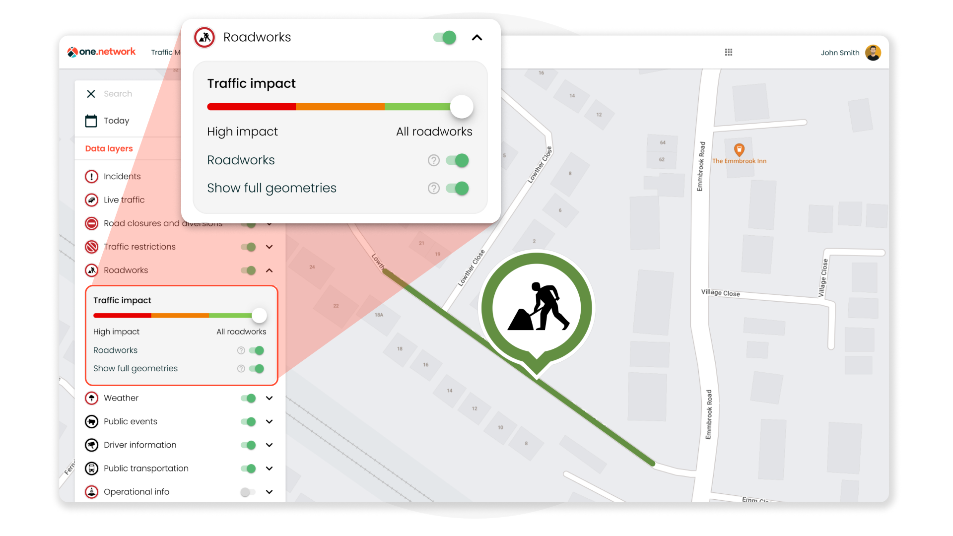
The one.network Map
In this release, we’re introducing a new ‘Full Geometries’ data layer to the one.network map. This new data layer will allow all one.network subscribers to view full geometries for roadworks and permits on one.network from the following systems and databases:
- Street Manager
- EToN
- Scotland Street Works Register
- NTIS
- NOMS
This more comprehensive view of spatial permit data on the map should help enhance the planning experience for one.network users.
Other improvements for the map in this release include:
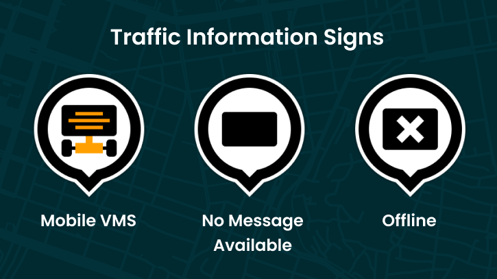
- A new layer key for Traffic Information Signs (VMS) under the ‘Driver Information’ data layers group. This will aid users in quickly identifying the status of Traffic Information Signs across the network. Hit the question mark next to the Traffic Information Signs data layer to expand the key!
- A fix so that width, length and height restrictions will display correctly on road event callouts. Input validation now ensures that only numerical values can be entered and displayed, thereby improving data integrity and platform usability.