Overview
This May, we’re bringing you a big update that will transform how you choose to view information on our map. We’ve also made some small improvements and additions to our Traffic Management, Live Link and Plan Share modules.
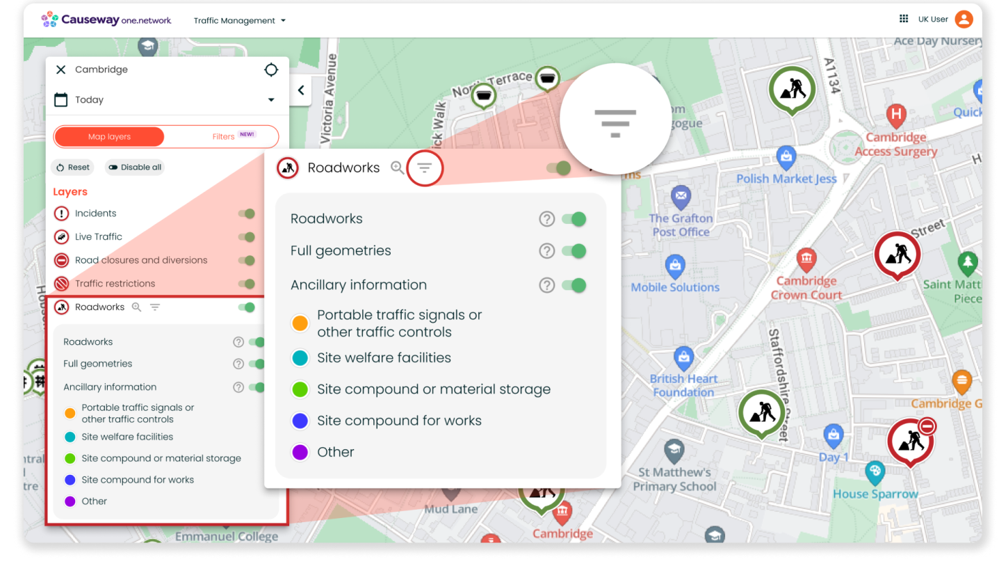
Introducing Advanced Map Layer Filters
Our development team have been working hard behind the scenes to bring you data filters that will make searching our map faster and easier. These new filters will allow you to tailor your map view based on categories such as work status, responsibility, sector and more.
By giving you more granular control over what is visible on the map, we’re streamlining the navigation experience and improving the efficiency of your planning and operational tasks.
Organisations that subscribe to Causeway one.network can access these filters without any restrictions. Non-subscribers can use the filters for up to 30 minutes daily; however, login to the platform is required.
You can access the Filters from the new ‘Filters’ tab and easily toggle between here and your regular ‘Map Layers’.
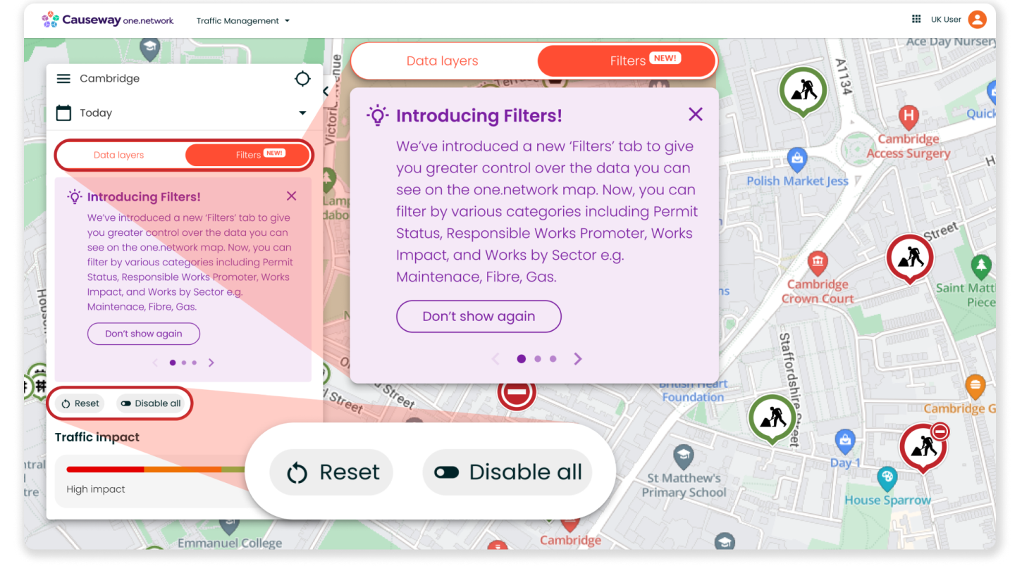
Let’s take a look at all the filters in more detail.
First, you’ll find the ‘Traffic Impact’ slider which lets you adjust the visibility of road event data on the map based on its potential impact severity. This slider previously lived under the ‘Roadworks’ map layer but now situated under filters also affects the Live incidents, public events and weather data layers.
You can use this slider without limits, regardless of whether your organisation subscribes to Causeway one.network.
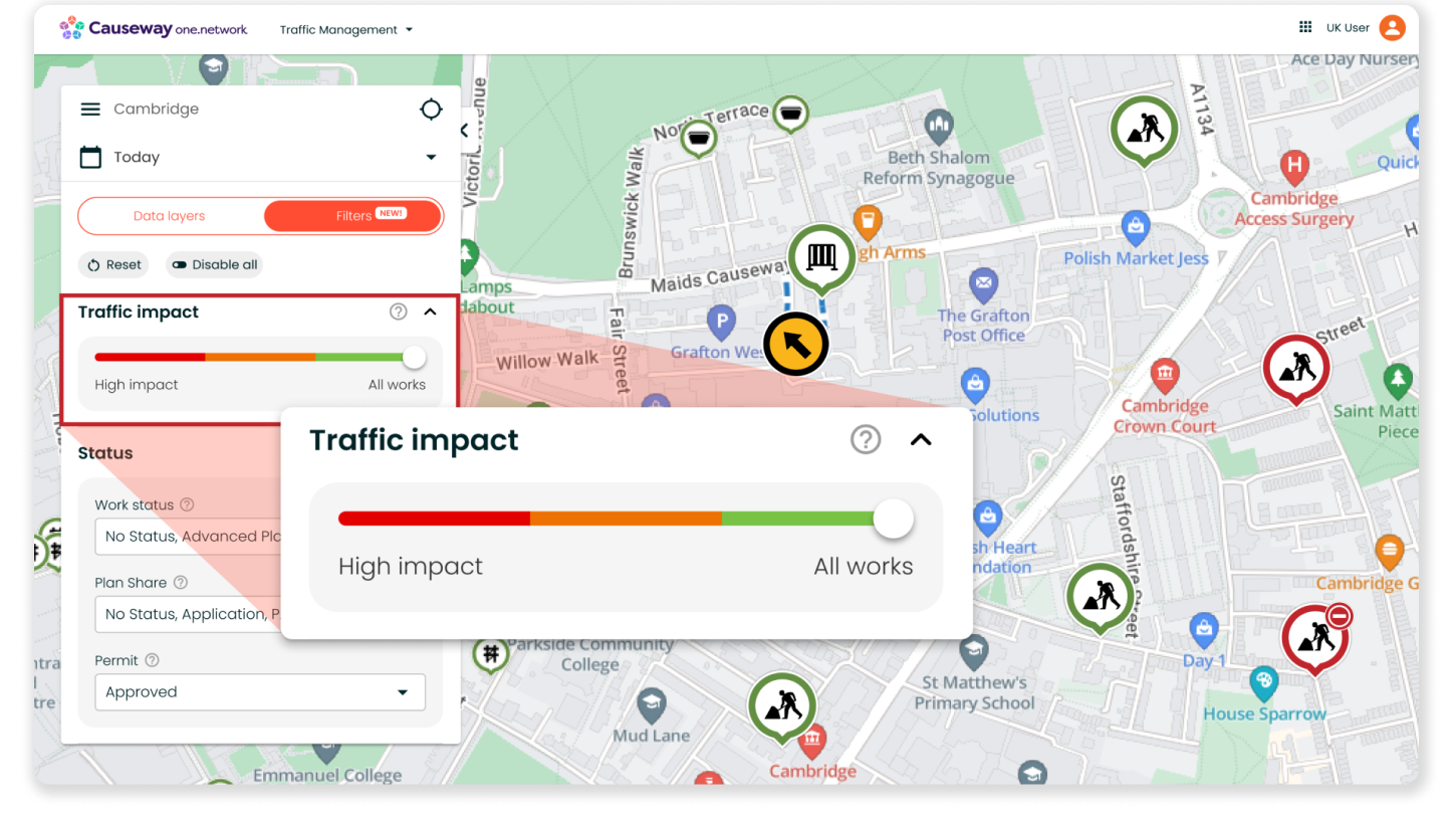
Below the slider, you can see all your filter options. These include:
Work Status
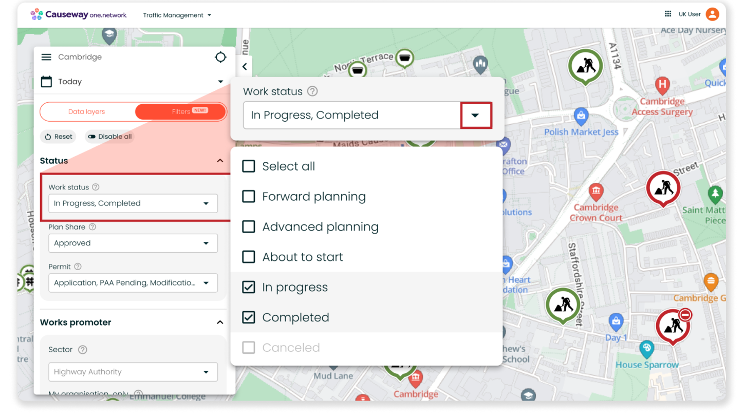
This filter allows you to filter which roadworks are visible based on the following status options:
- No Status
- Forward Planning
- Advanced Planning
- About to Start
- In Progress
- Completed
- Cancelled
This filter will help you with coordinating and keeping track of roadworks, providing an accurate, up-to-date view of activity on the network depending on its status.
Permit Status
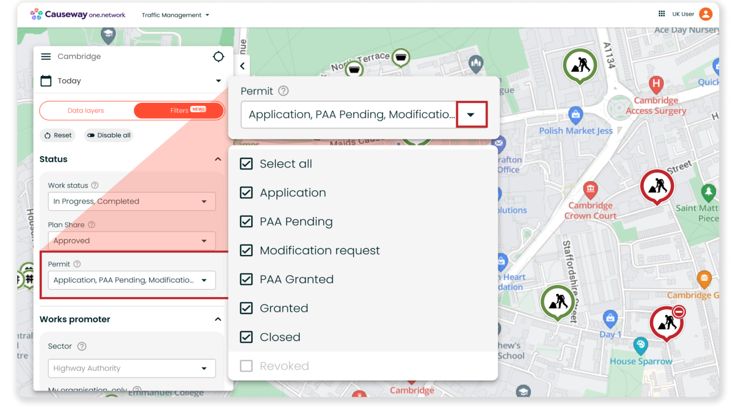
This filter can be used to filter roadworks by their permit status. The options include:
- No Status
- Application
- PAA Pending
- Modification Request
- PAA Granted
- Closed
- Revoked
Like ‘Work Status’, this filter will help you with coordinating street works but instead by offering distinct visibility of road activity based on its permit status.
Sector
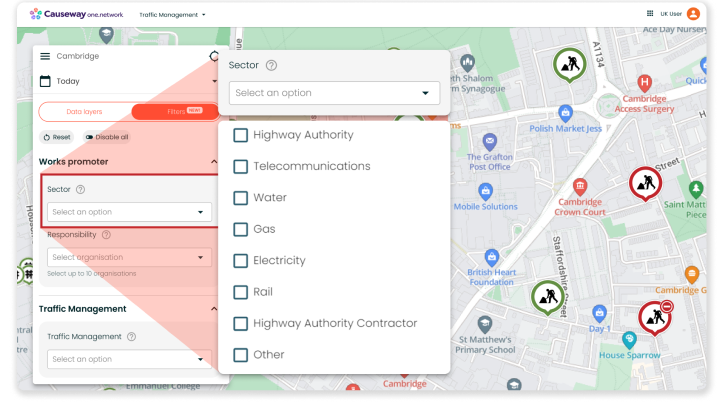
This filter allows you to view roadworks based on the sector they are related to according to the ‘Responsible organisation’ on the callout. The sector options include:
- Highway Authority
- Telecommunications
- Water
- Gas
- Electricity
- Rail
- Highway Authority Contractor
- Other
The 'Other’ option encompasses:
- Event organisers
- National infrastructure software systems
- Engineering contractors
- Petroleum transmission
- Bus operators
- Emergency services
- Tram/Tube
- No sector
This filter can be particularly helpful for utilities during the street works planning stage. For example, if a gas network operator needs to lay some new pipes on a particular street, they can use the Sector filter to view street works being conducted by other utilities to help identify collaboration opportunities.
Responsibility
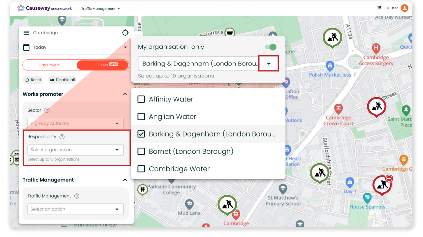
The ‘Responsibility’ filter lets you refine the road events shown on the map according to the responsible organisation. This includes roadworks, live incidents, weather incidents, public events, traffic retrictions and road closures and diversions.
Filter by 'My organisation only' to view events your organisation is responsible for, or select up to 10 organisations to get a filtered view of their road events on the map.
You can swiftly search organisations by name for easy access and also have the option to filter by road events with ‘No responsible organisation’ assigned.
Whether you’re planning street works or answering public enquiries, this filter can help you get a clear view of where your organisation is currently active on the network. For users at local highway authorities, you can use this filter to quickly check up on permit conditions for works being conducted by a particular utility or contractor in your region.
Traffic Management
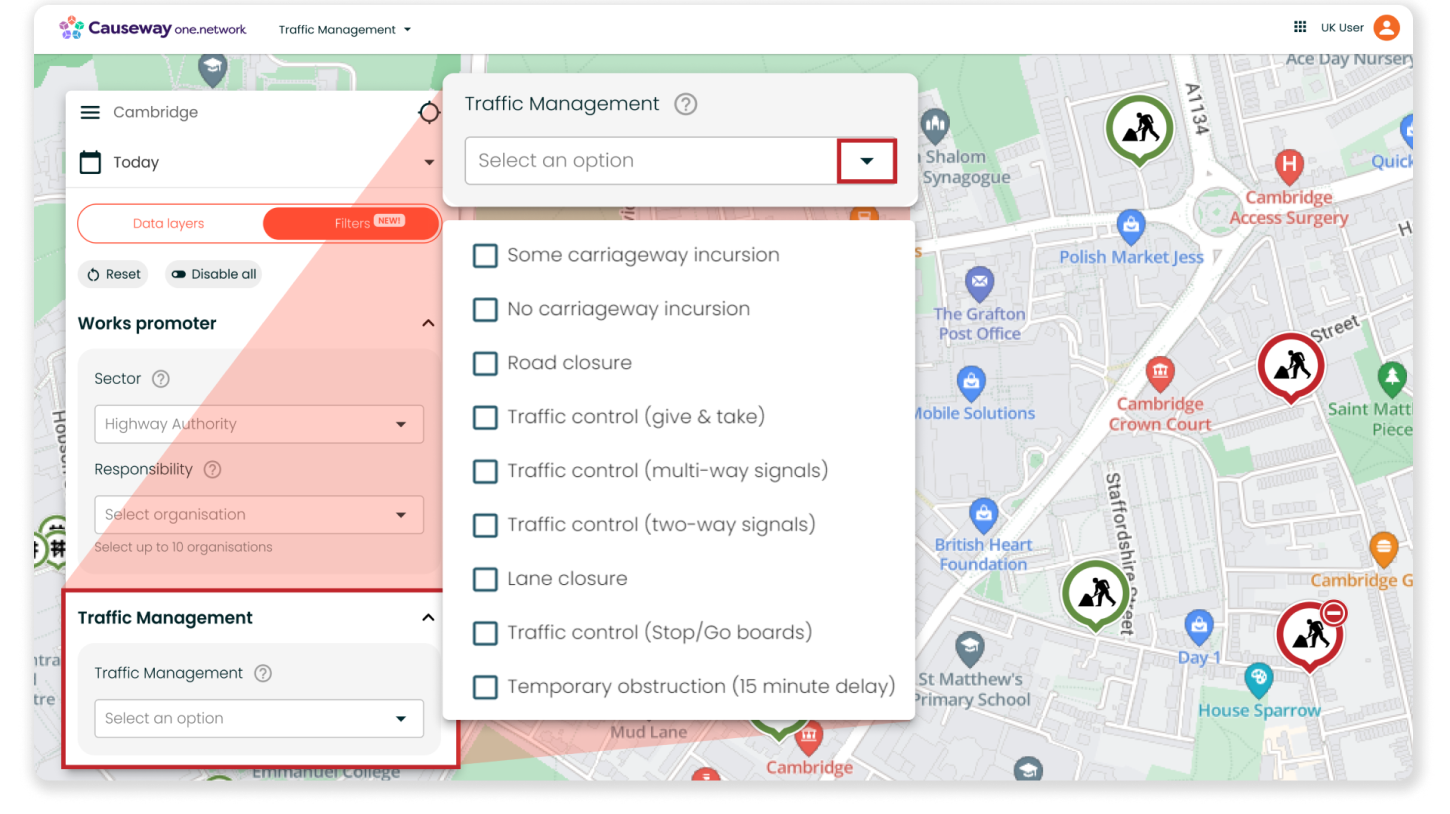
With the Traffic Management filter, you can filter road events by their traffic management type. This includes:
- Some carriageway incursion
- No carriageway incursion
- Road closure
- Traffic control (give & take)
- Traffic control (multi-way signals)
- Traffic control (two-way signals)
- Lane closure
- Traffic control (Stop/Go boards)
- Temporary obstruction (15 minute delay)
Plan Share Status
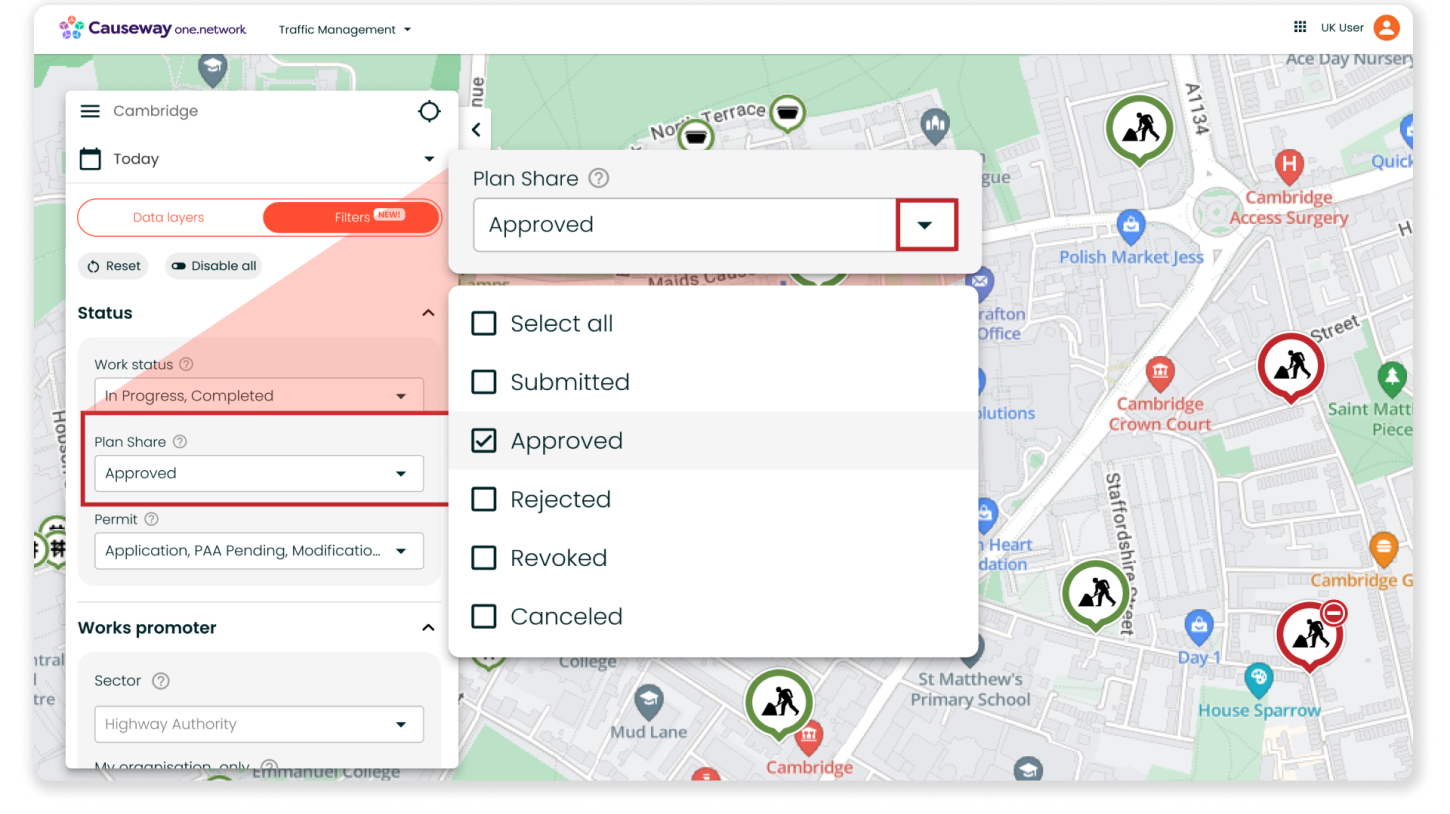
Our Plan Share module streamlines the digital submission of traffic management plans and TTROs, empowering utilities to submit applications directly to the highway authority through Causeway one.network. The highway authority can then efficiently review and publish the plans on the map.
For customers of this module, you’ll now have access to a new filter that enables you to filter road activity based on its ‘Plan Share’ status. This affects the roadworks, public events, traffic restrictions and closures and diversions layers, and has the following options:
- No Status
- Cancelled
- Submitted
- Rejected
- Approved
- Granted
- Revoked
This filter will be particularly valuable for highway authorities when approving TTROs, allowing for easy identification of potential conflicts between applications. Similarly, utilities and contractors can use the filter to help spot clashes prior to submitting traffic management plans.
By using this filter in conjunction with the ‘Responsibility’ filter (more information below), utilities and contractors can also set the map to only display street works by ‘My organisation only’ and those that have been ‘Rejected’ by the highway authority, allowing planners to quickly spot which projects and permits need attention.
Some important things to note
- Currently, you will still be able to access and use the ‘Forward Planning Roadworks’ map layer. However, this layer will be removed in a future release. After this, the only way to filter your view of Forward Planning Roadworks on the map will be via the ‘Work Status’ filter from the ‘Filters’ tab.
- You can remove all filters by clicking the 'Disable all' button. This action will clear all filter selections. Alternatively, selecting 'Reset filters' will restore the filter options to their default settings.
- To determine if a map layer is being affected by a filter, look for a small icon with three lines adjacent to the map layer.
- Filters do not disable layers. If you have the ‘Road closures and diversions’ map layer enabled and have filtered by the ‘Water’ sector, the map will show you road closures and events associated with the ‘Water’ sector.
- The filters tab will be present on all Causeway one.network embed maps, allowing users to modify solely the Traffic Impact slider. Your selected default filters will continue to function in the background, ensuring the same view as before the introduction of filters.
Other improvements in this release
- New shoulder closure and change lane direction features for Traffic Management and Live Link
We have also introduced a new 'shoulder closure' feature for our Traffic Management and Live Link modules! Now, you can conveniently plan and plot shoulder closures just like road and lane closures. In addition, we’re adding the ability to alter the direction of travel for lanes.
This new functionality extends to our Live Link mobile app as well; if you already have the app downloaded, the app will automatically prompt you to update to the latest version so that you can access this feature.
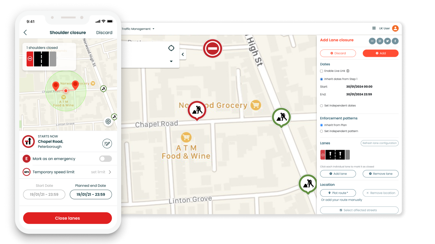
Please take note that while shoulder closure data created using Live Link will be communicated to sat-nav providers, lane direction changes will not as this is intended for internal use only.
- National Highways is now available as a ‘Works Responsibility’ Option in Traffic Management Step 1
If you work for a local highway authority and are plotting roadworks in your region but on a highway that is owned by National Highways, you will now have the option to select National Highways as the ‘Works Responsibility’ in Step 1 of Traffic Management.
This enables clearer communication with the public and stakeholders regarding roadworks managed by National Highways in your region.
- JPGs, PNGs and larger file size capabilities for Traffic Management and Plan Share
You’ll now be able to upload JPGs and PNGs in Step 3 when using Traffic Management or Plan Share. We’ve also increased the file size capability, allowing you to upload documents up to 25MB.
- A fix for edits to closure names and geometries in Traffic Management and Plan Share
When using our Traffic Management or Plan Share modules to edit a closure, the closure name is automatically filled with the location of the closure geometry. However, users often prefer to provide a more descriptive, custom name. Previously, modifying the geometry would cause the custom name to be lost. We have addressed this issue by implementing a fix that ensures the custom name input remains intact even when the geometry is altered.
If you have any questions on anything included in this release, please contact support@one.network.